Grilled Cheese

ExploreLog inSign up
Terms of UsePrivacy PolicyCommunity StandardsHelpGet the app

Grilled Cheese is a product of Village Compute

Version devBuilt at: 2026-10-10 01:38:52 EDT

Explore

PostsPeople
LatestRanked
@pnsn1.bsky.socialOct 9, 2026, 9:30 PM

Happy #FieldworkFriday! The PNSN field crew upgraded the battery bank at BURLY this week. BURLY contributes to Shake Alert earthquake early warning and serves as a repeater for seismic data transmitted by radio from EDM at Mt. St. Helens and WATCH near Mt. Rainier.
A seismic station with a solar panel and radio transmitters on a mountain ridge in the foreground and a view of Mt Rainier in the distance under a blue sky.Another view of the station with a metal box under the solar panel and Mt St Helens visible in the distance.Another view of the solar panel with a PNSN field team member working on it.A man in a PNSN t shirt working inside the open metal box at the base of the station, with wiring and tools visible inside.
@uaf-oarc-alaska.bsky.socialOct 9, 2026, 8:58 PM

This week we are analyzing seawater samples collected during the NOAA Fisheries Northern Bering Sea survey! #FieldworkFriday #OceanAcidification 🧪🌊🦑🙌

📸 J. Gann

Four oceanographers in waterproof gear, steel toed boots, hard hats, and life jackets show enthusiasm for ocean going field work aboard a research vessel in the Northern Bering Sea!
@nvseismolab.bsky.socialOct 9, 2026, 6:25 PM

What happens after a #wildfire is contained?
This #FieldWorkFriday, the NSL field team partnered with BLM and the Forest Service to install a new remote wildfire monitoring camera at Santa Rosa Peak.
—
#wildfiresafety #sciencetechnology #nevada #nevadascience

@cires.colorado.eduOct 9, 2026, 5:25 PM

CIRES scientists use all sorts of tools to understand environmental change.

Researchers at CIRES' @earthlabcu.bsky.social use drone imagery to track changes in vegetation cover, fire, and more. This week's #FieldworkFriday photos shows scientists preparing for a drone flight.

📸: Ty Tuff/CIRES

Photo looking down on a researcher carrying a white and orange GPS unit in a wooded areaTwo scientists wearing orange, high-visibility vests stand by a truck parked in front of a line of pine trees. One scientist has his hands in his hair. A drone sits on a gravel road in the foregroud.Two scientists wearing orange, high-visibility vests walked down a slop. One is carrying a GPS unit on their shoulder.
@archanthlancashire.bsky.socialOct 9, 2026, 1:27 PM

Let’s have a very THEMATIC #fieldworkfriday today! starting off with Lowther Castle up near Penrith, the lakes, and all that #archaeology… some of which is, obvs, The Archaeology of… poo 💩🏺🤘https://youtube.com/playlist?list=PLXSJRrw1enbQYishJwl6MSbkdjqToG_JK&si=zDp5i3w1lwKM7lN1

@aquastemconsulting.bsky.socialOct 2, 2026, 9:37 PM

Swamp sunflowers 🌻 on the #stjohnsriver, #florida

#aquastemconsulting #environmentalconsulting #environmentalscience #fieldworkfriday #airboat #survey

@akearthquake.bsky.socialOct 2, 2026, 9:20 PM

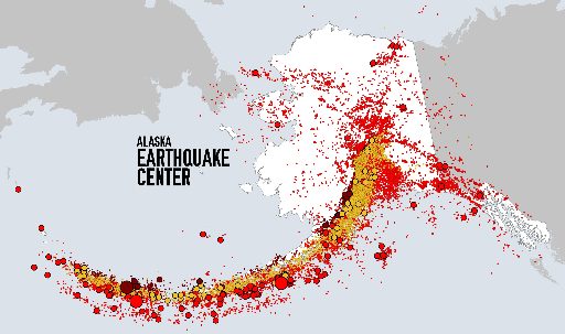
It's our final #FieldWorkFriday of the season! Today, we revisit Nikolai where our local school partner 🏫 allowed the team to build the tower shown here. It receives the data streamed by radio wave 📻️ from 2 remote stations, K20K and L20K, each about 40 miles from Nikolai. Stay tuned 📡 for TriviaTues

@pnsn1.bsky.socialOct 2, 2026, 8:00 PM

Happy #FieldworkFriday! Satellite comms, like the Starlink at PASS, lets us reliably transmit data where cell coverage is poor. But satellite dishes are power hogs, so we often use a short radio hop from a solar-powered seismic site to an AC-powered site with a satellite dish.

Wide outdoor rural scene under bright blue sky with large white clouds.

Foreground left: side of small white shed. Beside it stands weather-monitoring equipment mounted on wooden posts: metal sensor box, cables, a tall pole, and rectangular solar panel at top.

Center: small leafy fruit tree in grassy field. Beyond it stretches open pasture, enclosed by thin wire fencing and wooden fence posts.

Background: dense evergreen trees line field. Low forested hills rise at far right. Sunlight casts long shadows across grass. Photo feels clear, peaceful, and outdoorsy.Wide outdoor pasture under cloudy sky.

Left: person wearing cap, plaid shirt, jeans, standing in grass and looking toward equipment.

Center: Underground Depart box with the seismic sensors

Right: solar-powered monitoring station mounted on stone-and-wood base. Two solar panels angle upward. Below them are weather sensors, pipes, wires, and small instruments.Open metal electrical control box mounted outdoors. Inside, many red, black, blue, green, and gray wires run between terminal blocks, connectors, power supplies, and other electrical components. Wires are bundled and coiled near top and right side. A horizontal grounding bar with several black cable clamps crosses middle. Bottom section contains additional terminal blocks and a larger gray control module. Sunlight creates a rainbow-like glare across image. Wooden support posts and outdoor grass visible around box.Tall metal pole stands beside wooden post, with rectangular solar panel mounted at top. Coiled conduit and electrical wiring run along pole, with small round instrument attached near middle. Aluminum ladder leans against structure in foreground. Beyond it, sunny pasture, rustic fence, evergreen forest, and wooded hills sit beneath bright blue sky with scattered white clouds.
@greatbasinbirds.bsky.socialOct 2, 2026, 6:24 PM

Field manual amendment-“Avoid oncoming traffic while rescuing venomous lizards from the road.” #FieldWorkFriday #GilaMonster #herps

Gila Monster in a cooler, after being rescued from the road.
@bayquest.bsky.socialOct 2, 2026, 5:01 PM

The more we listen in to the sea, the better we can understand the impact of noise pollution on wildlife. Happy Friday Everybody!

Here we are demonstrating #SpotterSound hydrophone tech to young sailors aboard the schooner Seaward! 🎧⛵️

#FieldworkFriday #BayQuest #SeaSoundsProject #SanFranciscoBay

@cires.colorado.eduOct 2, 2026, 4:01 PM

CIRES scientists investigate climate and environmental changes from pole to pole.

In November 2019, CIRES scientists and colleagues installed a GPS on the George VI Ice Shelf on the Antarctic Peninsula. #FieldworkFriday

📸: @alibanwell.bsky.social / CIRES

A scientist in winter gear stands near 2 snowmobiles and a GPS unit on a snowy and icy landscape with high, snowy mountains in the background.
@akearthquake.bsky.socialSep 25, 2026, 10:15 PM

It’s #FieldworkFriday! Field team members Shah Khan and Cade Quigley visited Nikolai recently to build a new relay station from the ground up! Thank you to Top of the Kuskokwim School for hosting the new station. Khan and Quigley also gave a presentation to students and practiced earthquake safety!

Two people smile and give a thumbs-up beside a pole-mounted Alaska Earthquake Center data relay station labeled "Earthquake Monitoring Station," with antennas and wiring visible.Students and an adult sheltering under desks during an earthquake drill in a classroom with red chairs, whiteboard, and Alaska Earthquake Center logo.
@pnsn1.bsky.socialSep 25, 2026, 9:00 PM

Happy #FieldworkFriday! The highest-elevation station in the continental US, St Andrews Rock (STAR) on Mt Rainier, sits above 11,000ft. Steep terrain, erosion, and changing snow & ice are forcing a move down ridge. This visit helped identify a safer, more stable site nearby.

@earthscope.orgSep 25, 2026, 7:01 PM

Happy #fieldworkfriday!

EarthScope engineers ventured out to Yellowstone National Park to service monitoring stations around the park.

@uaf-oarc-alaska.bsky.socialSep 25, 2026, 4:45 PM

#FieldworkFriday 🧪🌊🦑🦀

@uafairbanks.bsky.social graduate student Teighan Shore is working with the #BeringSea Research Center on a project studying #OceanAcidification and red king crab. We are analyzing seawater samples for their project.

www.beringseacampus.com

Bering Sea Research Center staff observe adult female crabs just after arrival into the hatchery. 

https://www.beringseacampus.com/
The Bering Sea Research Center accommodates academic researchers, institutional partnerships, government agencies, and private research focused on Arctic, marine and coastal ecosystems. 

We support interdisciplinary collaboration across Indigenous and academic, federal, state, and community-based initiatives, providing infrastructure that advances research excellence, strategic program implementation, and long-term Arctic engagement.
@geographicalassoc.bsky.socialSep 22, 2026, 3:16 PM

What’s the best field trip you’ve ever taken a class on and what made it so memorable?

#geography #geographyteacher #fieldworkfriday

@akearthquake.bsky.socialSep 18, 2026, 11:16 PM

Happy #FieldworkFriday! We maintain seismic stations at several of Alyeska's Trans Alaska Pipeline System pumpstations. This week the field team upgraded the data digitizer (which makes data ready to transmit) at station PS08 and performed "shake tests" to ensure it would alert Alyeska's systems.

A technician sets up seismic monitoring equipment inside a server rack, connecting and organizing multiple network and sensor cables among tangled cords, with the "Alaska Earthquake Center" label visible in the lower-right corner.
@pnsn1.bsky.socialSep 18, 2026, 10:00 PM

Happy #FieldworkFriday! Our field crew headed to Mt. Rainier to perform maintenance at RCS, one of our seismic stations. Along the way, they enjoyed stunning views of the snow-covered peaks.

A rugged, snow-dusted mountain ridge rises beneath a deep blue sky. There is also station sits along the rocky slope over looked by clear blue sky.Photo of a bunch of boxes and supply
photo of Field crew posing with a thumbs up
@uaf-oarc-alaska.bsky.socialSep 18, 2026, 6:28 PM

#FieldworkFriday #AlaskaSky 🧪🌊🦑
This week we are analyzing seawater samples collected by @uafairbanks.bsky.social oceanographers partnering with the National Park Service to detect #OceanAcidification in #GlacierBay and #WrangellStElias.

www.nps.gov/articles/000...

University of Alaska Fairbanks oceanographers deploy equipment to observe seawater properties such as temperature, salinity, and dissolved oxygen. The vertical sample bottles collect seawater at various depth to later analyze for chlorophyll, nutrients, and carbonate chemistry.

This oceanographic research station is in a glacial fjord in the northeast Pacific offshore Alaska.
@bayquest.bsky.socialSep 18, 2026, 3:19 PM

Tomorrow's the Day! Grab a bucket & trowel, help us clean up our shoreline and meet hundreds of new friends!

9am-12noon; Middle Harbor Shoreline Park

Happy Friday!

(Photo: Replacing invasives with sustainable native plants near the Port of Oakland)

#FieldworkFriday #BayQuest #ShorelineCleanup

Load more