Wow. A recon mission into #Polo just measured a wind speed of 215 mph a few thousand feet above the surface.
 @gporterwx.bsky.social
 @gporterwx.bsky.social
Wow. A recon mission into #Polo just measured a wind speed of 215 mph a few thousand feet above the surface.
 @nhc.weather.im
Hurricane #Polo ADVISORY 22 issued. #Polo remains a powerful category 5 hurricane. Link
 @stormysoundwx.bsky.social
Currently, #hurricane #Polo (right) has yet again intensified to category 5, and is interacting with Hurricane #Odalys which is a category 3. on the left, Nolo threatens #hawaii

 @elprager.bsky.social
#Nolo forecast to become major CAT4 hurricane impacting Hawaii, #Polo returns to CAT5, and major #NorEaster already causing problems along the East Coast in today's update for the All Hazards Consortium. Please stay aware, prepare, and stay safe. 🧪🌀
 @iweather.bsky.social
🌀 Tropical Pacific moisture associated with Major Hurricanes #Polo (east) and #Odalys (west) is being channeled into the Plains by the upper-level winds. The remnants of #HurricanePolo will contribute to the uptick in precipitation chances next week.
iweathernet.com/list-current-tropical-storms


 @meteopedagogie.bsky.social
Résumons : #Polo va évoluer vers #BajaCalifornia avec impact potentiellement significatif, #Odalys s'affaibilira à l'Ouest, la future #Rachel est en organisation au Sud-Est, et le possible #Simon apparaît aussi au Sud-Ouest. Cette saison cyclonique 2026 est hallucinante
 @cyclonetracking.bsky.social
Hurricane #Polo is still a DANGEROUS CATEGORY 5 but is expected to gradually weaken as it curves towards Baja California, still delivering Moderate Impacts. Slight Impacts are expected for Sonora, Arizona, Utah, and New Mexico! Will likely have a stream up later tonight!

 @wxatom.bsky.social
Meanwhile, Polo has put on a show today. The storm has sustained Category 5 strength for most of the day and has been thoroughly sampled by the NOAA Hurricane hunters. #Polo
 @mikecohan.bsky.social
4PM Pacific:
#Polo looks like it may be undergoing it's 2nd Eyewall replacement cycle as a Cat 5 storm. The Eyewall is the least defined I have seen it in days.


 @ryanhoke.bsky.social
Could a Pacific #hurricane be partially responsible for #Kentucky and Southern #Indiana's next rain chance? #Louisville #polo #hurricanepolo
 @sociedad-noticias.bsky.social
🌀 El huracán Polo continúa como categoría 5 con vientos de 285 km/h y rachas de 350 km/h. Nayarit, Jalisco, Colima, Michoacán, Sinaloa y BCS tendrán lluvias, viento y oleaje. Autoridades piden extremar precauciones. #Polo
 @joeloffair.bsky.social
WOW👀 Hurricane #Polo is a major Cat 5 hurricane this Friday evening with max winds ~180 mph, about 350 miles SW of Puerto Vallarta.
It's likely to curve back toward the Baja of Cali. early next week, making landfall and bringing heavy rain into the Southern Plains next week! #ARwx #ARStormTeam


 @jimhladik.bsky.social
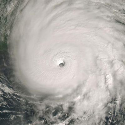
Quite the eye on Hurricane #Polo this morning. 🌀

 @cyclonicwx.bsky.social
#Polo remains a solid Category 5 per recon, but changes are afoot. A lot more bursting around the eye which can be an early tell that an eyewall replacement cycle will begin soon
@nhc.weather.imHurricane #Polo ADVISORY 21 issued. Noaa aircraft measures category 5 winds in #Polo. Link


 @bouldercast.com