

Grilled Cheese

ExploreLog inSign up

Alex Boreham

@cyclonicwx.bsky.social

75 Following2.4k Followers

Tropical meteorologist, B.S. FSU, amateur web, Python, & GrADS programmer. Also known as Not Sparta

PostsRepliesMedia
@cyclonicwx.bsky.socialOct 12, 2026, 11:50 PM

I got creative with this one! For the mapping system I use MapLibre. Very good for this sort of thing. I package up data in Python into specialized files that I can read client side and it plots onto the map. Proud of how much I managed to cut down on bandwidth usage and still make it run smooth

@cyclonicwx.bsky.socialOct 12, 2026, 9:19 PM

Want to use one elsewhere? Export it to a CPT file or use the automatically generated Python snippet to use it for your own plots. Check it out by looking through the layers in the bottom right and clicking on the product you want to change

@cyclonicwx.bsky.socialOct 12, 2026, 9:19 PM

New feature for cyclonicwx.com/interactive/: you now have total freedom with colormaps! Choose from the many pre-existing ones, create your own with a new colormap editor, or upload a CPT file and instantly import its colormap.
Photo, no descriptionPhoto, no descriptionPhoto, no descriptionPhoto, no description
@cyclonicwx.bsky.socialOct 9, 2026, 7:13 PM

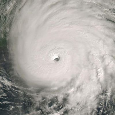
The shear is here and #Isaias is feeling it. Note the "push" of upper westerlies on its outflow. It's strong enough to have made the eyewall very asymmetric, but there is not a lot of time for it to weaken too much now. Additionally, the tornado threat is beginning to the east with waterspouts there

Photo, no descriptionPhoto, no descriptionPhoto, no descriptionPhoto, no description
@cyclonicwx.bsky.socialOct 9, 2026, 3:22 PM

#Isaias has continued to strengthen thanks to the trough interaction and is a major hurricane. However it does seem to finally be feeling some of the shear and the intensification has stalled. It will still be impactful at this point, even outside the core! Risk of tornadoes to the east

Photo, no descriptionPhoto, no description
@cyclonicwx.bsky.socialOct 8, 2026, 4:20 AM

This means Isaias may still be able to continue intensifying in the face of it until it gets overwhelmingly strong by Friday, when weakening is expected

@cyclonicwx.bsky.socialOct 8, 2026, 4:20 AM

#Isaias has continued to strengthen, now the latest first hurricane of the satellite era. Microwave earlier today has suggested a lopsided core tilted by shear, and the shear is easily seen on this loop. However, it is also highly divergent.

@cyclonicwx.bsky.socialOct 7, 2026, 9:10 PM

#Isaias seems to be a bit more misaligned now than earlier as shear tries to get the best of it. We'll see if it can develop a core before the shear gets too strong, which would make it stronger and more resilient, otherwise will become rather sloppy. High variance

Photo, no descriptionPhoto, no description
@cyclonicwx.bsky.socialOct 7, 2026, 5:48 PM

The TDR for #Isaias is in, showing its structural improvement. There's a strong SW side, with a clear RMW that it will try to build a core off of. The center relocation has gotten it more aligned as well, with tilt down to 10-15 km. Certainly explains the faster strengthening

Photo, no descriptionPhoto, no description
@cyclonicwx.bsky.socialOct 7, 2026, 5:09 PM

#Isaias is getting itself together today. The newest recon finds a more coherent center, with some stronger winds close to the center and a 4mb drop in pressure from 2 hours ago. With the structure improving we'll likely see some intensification today. TDR will be interesting

Photo, no descriptionPhoto, no description
@cyclonicwx.bsky.socialOct 6, 2026, 10:35 PM

#TD9 is here. It already commands a fairly large area of rotation and some decent rotation near the center. It has some decent conditions through the next few days. As it approaches the north-central Gulf Coast at the end of the week shear will increase, but worth watching for an impactful hurricane

@cyclonicwx.bsky.socialSep 29, 2026, 4:45 AM

Over the next few days, we'll have a pretty solid westerly wind band north of the equator through essentially the entire Pacific. Very easy to spin up TCs in such an environment! El Nino in total control at this point

@cyclonicwx.bsky.socialSep 28, 2026, 2:58 AM

Another day, another great satellite presentation in the Pacific. Today it's #Nolo, which has gotten into an increasingly favorable environment and has cleared out a nice large eye. Look at the low clouds spinning around! Expected to reach Category 5, and thankfully no land threat

@cyclonicwx.bsky.socialSep 27, 2026, 6:06 AM

#Surigae really got itself together. Eye trying to clear on satellite, JMA radar composite has solid eyewall though it could really wrap the more intense precipitation around the entire thing

@cyclonicwx.bsky.socialSep 27, 2026, 1:42 AM

Been too long since I've seen this banger

@cyclonicwx.bsky.socialSep 26, 2026, 9:52 PM

Keeping up the momentum with some new features. First is split screen, which is good to see different kinds of data for a storm without overlapping or watch 2 at once. And next is the ability to save or load a view so if you have multiple frequent setups it is now very easy to spin them up!

Photo, no descriptionPhoto, no descriptionPhoto, no description
@cyclonicwx.bsky.socialSep 26, 2026, 5:03 PM

Some crazy stuff going on with the warm pool right now. You can even see it in the raw temperature plot, reversing the usual vertical gradient. May see Nino 1+2 and Nino 3 warm even further as this surfaces

Photo, no descriptionPhoto, no description
@cyclonicwx.bsky.socialSep 26, 2026, 12:41 AM

Plus, you can now see TDR just like the original page! But here, you can create cross sections that give you an even better picture into the system. Draw your own cross-section axis, match it to the flight path, or plot it along the shear axis! Enjoy all the new data!

Photo, no descriptionPhoto, no descriptionPhoto, no descriptionPhoto, no description
@cyclonicwx.bsky.socialSep 26, 2026, 12:41 AM

Along with that, there is also a new graph like you can see in the recon page, but this one is interactive! Plus, the recon plots and their center drop pressures and derived winds are right there on the map for you to see.

Photo, no descriptionPhoto, no descriptionPhoto, no description
@cyclonicwx.bsky.socialSep 26, 2026, 12:41 AM

I've added lots of new ways to view recon data on cyclonicwx.com/interactive/, using the flexibility the map gives you! First are dots rather than the usual wind barbs. You can change these to display wind speed, temperature, and extrapolated pressure! The latter two change the mouseover value too.

Photo, no descriptionPhoto, no description
Older posts
Terms of UsePrivacy PolicyCommunity StandardsHelpGet the app

Grilled Cheese is a product of Village Compute

Version devBuilt at: 2026-10-13 22:15:16 EDT