Grilled Cheese

ExploreLog inSign up
Terms of UsePrivacy PolicyCommunity StandardsHelpGet the app

Grilled Cheese is a product of Village Compute

Version devBuilt at: 2026-10-15 13:20:56 EDT

Explore

PostsPeople
LatestRanked
Load more
@weatherken.bsky.socialOct 9, 2026, 4:23 PM

Hurricane Isaias update — now a Cat 3, will likely make landfall as a Cat 2 later tonight/early Saturday by the Alabama-Florida border. Storm surge to 9 ft in spots, rain totals pushing 15" for some, & multiple tornadoes.

Dangerous situation about to unfold by the Gulf Coast.

#tropics #isaias

@fllics.comOct 9, 2026, 4:21 PM

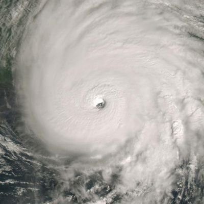
LIVE: Hurricane Isaias bears down on US Gulf Coast

A satellite view shows Hurricane Isaias — the first Atlantic hurricane of the 2026 season — bearing down on the US Gulf Coast. Video is courtesy of NOAA. #hurricaneIsaias #Isaias #USgulf #noaa #weather Keep up with the latest news from around the…

@netasgardcanadaen.bsky.socialOct 9, 2026, 4:17 PM

U.S — over 100,000 residents ordered to leave as storm intensifies near gulf coast #Hurricane #Isaias #HurricaneIsaias #US #News #Breaking

@nhcbot.bsky.socialOct 9, 2026, 4:13 PM

11 am CDT Tropical Cyclone Update for Hurricane #Isaias: https://www.nhc.noaa.gov/text/refresh/MIATCUAT4+shtml/091555.shtml https://x.com/NHC_Atlantic/status/2108587497013879225

Photo, no description
@es-ve.pds.netasgard.comOct 9, 2026, 4:08 PM

México — Huracán Simón alerta por lluvias torrenciales en Guerrero y Michoacán #Isaias #Isaías #México #Simón #News #Breaking

@nws.noaa.govOct 9, 2026, 4:07 PM

Life-threatening storm surge & devastating winds are likely along the Florida Panhandle and Alabama coasts.Residents under evacuation orders should leave IMMEDIATELY and follow advice from local officials.

#Isaias remains a Cat 3 storm with max sustained winds of 120 mph as of 11am CT, 10/09/2026.

Hurricane Preparedness: Develop an Evacuation Plan   Main Text Items:Find out if you live in an evacuation zone   Plan several routes   Have a go bag for supplies   Plan for your pets   Follow evacuation orders if given   Photo Description:
The left panel features a close-up photo of a blue road sign reading "HURRICANE EVACUATION ROUTE" with a hurricane symbol and a white right-arrow sign underneath. The background shows dark, overcast skies.
@nhc-atlantic.extwitter.linkOct 9, 2026, 4:03 PM

11 am CDT Tropical Cyclone Update for Hurricane #Isaias: t.co/LcsA3EZYXU

🔗 www.nhc.noaa.gov/text/refre...

Photo, no description
@kautious.comOct 9, 2026, 4:02 PM

Isaias reached Category 3 Oct. 9, with winds near 120 mph, approaching the northern Gulf Coast.
Friday evening landfall was forecast; evacuation orders were issued amid 5–7 to 6–9 ft surge estimates, flooding and possible tornadoes.
Impacts could extend inland. #Isaias #GulfCoast

Financial insights visualization: Hurricane Isaias rapidly intensified into a major hurricane: multiple posts on October 9 reported Category 3 status and winds near 120 mph as it approached the northern Gulf Coast., Life-threatening coastal and inland hazards: posts warned of dangerous storm surge, damaging winds, flooding rain, and possible tornadoes across the Florida Panhandle and Alabama coast.
@dutchtulips.bsky.socialOct 9, 2026, 3:44 PM

#isaias is now a category 3 and due to make landfall in the gulf coast tonight. yikes.

@global-news-2024.bsky.socialOct 9, 2026, 3:42 PM

📰 El Niño's storm-killer winds and climate's warming waters in fight over future of Hurricane Isaias

And the storm's tilt and eye show who's winning.

Source: PBS NewsHour | Read story

💬 What are your thoughts on this development?

#TechBluesky #Isaias #Hurricane

@lindseyslatertv.bsky.socialOct 9, 2026, 3:39 PM

Hurricane Isaias became a MAJOR hurricane earlier this morning - aka Cat 3 or above.
Landfall will be tonight over Pensacola and the Gulf Shores.
#hurricane #isaias #cat3 --10.9.26-- 🌀

Photo, no description
@wisc-satellite.bsky.socialOct 9, 2026, 3:30 PM

30-second @noaa.gov #GOESEast Infrared images with plots of GLM Flash Points showed Hurricane #Isaias as it moved toward the Gulf Coast, reaching Category 3 intensity at 1220 UTC.

@nws.noaa.govOct 9, 2026, 3:30 PM

Along the coast, life-threatening storm surge from #Isaias is expected from the Mouth of the Mississippi River to the Suwannee River, Florida. The deepest water will occur along the immediate coast in areas of onshore winds, where the surge will be accompanied by large and dangerous waves.

Coastal forecast map showing predicted peak storm surge along the U.S. Gulf Coast from Louisiana to western Florida, with highest surge (6–9 ft) centered on the AL/FL border region.

Forecast Inundation Levels:6–9 ft (Orange): AL/FL Border to Grayton Beach   4–7 ft (Orange): Grayton Beach to Indian Pass   4–6 ft (Yellow): Dauphin Island to AL/FL Border; Indian Pass to Steinhatchee River   3–5 ft (Yellow): Lower Mobile Bay; Mouth of the Mississippi River to Dauphin Island; Steinhatchee River to Suwannee River   2–4 ft (Yellow): Upper Mobile Bay; Suwannee River to Yankeetown   1–3 ft (Blue): Lake Pontchartrain; Yankeetown to Egmont Key   1–2 ft (Blue): Morgan City to Mouth of the Mississippi River
@realkachelmann.bsky.socialOct 9, 2026, 3:27 PM

Ein Bild alle 30 Sekunden.

#Isaias

kachelmannwetter.com/de/sat/07588...

@nhcbot.bsky.socialOct 9, 2026, 3:25 PM

Oct 9: NHC Director Michael Brennan provides a LIVE update on Hurricane #Isaias from the National Hurricane Center: https://www.youtube.com/live/glPPVhlVo8k?si=GYK_blTljI6jTjfT https://x.com/NHC_Atlantic/status/2108577532354220402

Photo, no description
@nhcbot.bsky.socialOct 9, 2026, 3:25 PM

RT by @NHC_Atlantic: 10/09 10am CDT: A life-threatening storm surge from #Isaias is expected from the Mouth of the Mississippi River to the Suwannee River, Florida, where a Storm Surge Warning is in effect. Conditions will deteriorate throughout ... https://x.com/NHC_Surge/status/2108574427231277221

Photo, no description
@jeremymoses85.bsky.socialOct 9, 2026, 3:25 PM

#Isaias UPDATE 10:21 CDT

Isaias became a category 3 hurricane at 7:20am CT this morning. Winds are still 120 mph as of 10am CT.

Because of the alignment of the storm motion with the southwesterly shear, unfortunately Isaias is now expected to make landfall as a Category 3 hurricane.

@cyclonicwx.bsky.socialOct 9, 2026, 3:22 PM

#Isaias has continued to strengthen thanks to the trough interaction and is a major hurricane. However it does seem to finally be feeling some of the shear and the intensification has stalled. It will still be impactful at this point, even outside the core! Risk of tornadoes to the east

Photo, no descriptionPhoto, no description
@nhc-atlantic.extwitter.linkOct 9, 2026, 3:21 PM

Oct 9: NHC Director Michael Brennan provides a LIVE update on Hurricane #Isaias from the National Hurricane Center:

@paulheggenwx.bsky.socialOct 9, 2026, 3:21 PM

#Hurricane #Isaias is a major Category 3 storm, with 120mph sustained winds. Latest forecast no longer shows significant weakening before landfall, so it will likely still be a major hurricane when it hits the coast. @wbtv.com

Photo, no description